

— Blogs —
—Products—
 Consumer hotline +8618073152920
 WhatsApp:+8615367865107
Address:Room 102, District D, Houhu Industrial Park, Yuelu District, Changsha City, Hunan Province, China
Product knowledge
Time:2024-11-14 11:26:03 Popularity:360
In the vast natural world, hydrological and meteorological phenomena affect human life and the operation of society all the time. In order to accurately capture these ever-changing information, hydro-meteorological stations have come into being. Like sophisticated sentinels, they monitor the hydrological and meteorological conditions of the earth 24 hours a day, providing vital data support for human society.
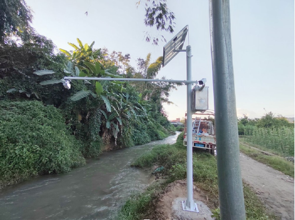
A hydrometeorological station, as its name suggests, is a comprehensive observatory that combines hydrological and meteorological observation functions. It is not only capable of monitoring meteorological elements such as temperature, humidity, barometric pressure, wind speed and direction in the atmosphere, but also capable of observing hydrological information, such as precipitation, evaporation, river level, and water flow rate. These observational data are of great value for meteorological forecasting, water resource management, disaster prevention and mitigation, and other fields.
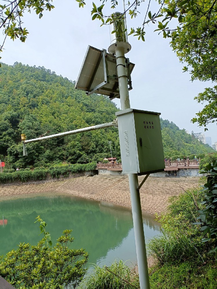
1. real-time: hydrometeorological stations can monitor and transmit hydrological and meteorological data in real time to ensure the timeliness of information.
2. Continuity: the hydrometeorological station can realize 24-hour uninterrupted monitoring, providing support for long-term data analysis.
3. Accuracy: adopting high-precision sensors and advanced data processing technology to ensure the accuracy of monitoring data.
4. Integration: the hydrometeorological station can be integrated with a variety of sensors to realize the synchronous monitoring of a variety of hydrological and meteorological parameters.
5. Adaptability: Designed to take into account the harsh environment in the field, it adopts corrosion-resistant materials, and part of the equipment supports solar power supply to ensure long-term unattended operation.
6. Modular design: hardware and software modularization, according to the different needs of flexible configuration and upgrading to meet specific monitoring needs.
1. data collection: collect rainfall, water level, flow rate, air temperature, humidity, wind speed and other hydrological and meteorological parameters.
2. data processing: process, analyze and store the collected data, and generate all kinds of reports and charts.
3. Early warning and forecasting: According to the monitoring data, issue early warning information on floods, droughts, storms and other disasters.
4. information transmission: through wired or wireless means, real-time transmission of monitoring data to the data center or relevant institutions for subsequent analysis and application.
1. meteorological sensors:
- Temperature Sensor: Measure the air temperature.
- Humidity Sensor: Measure air humidity.
- Barometric Sensor: Measures atmospheric pressure.
- Anemometer: Measures wind speed.
- Anemometer: Measures wind direction.
- Solar Radiation Sensor: Measures the intensity of solar radiation.
- Rain gauge: measuring precipitation, divided into standard rain gauge, tipping bucket rain gauge, etc. 2.
2. Hydrological sensors:
- Water level meter: monitor water level changes, including buoy water level meter, pressure water level meter, sonic water level meter, etc.
- Tachymeter: measure the speed and direction of water flow, including mechanical tachymeter, electromagnetic tachymeter, acoustic Doppler current meter (ADCP), etc.
- Evapotranspiration meters: measure the rate of evaporation from the water surface.
- Water quality sensors: monitor various water quality indicators in the water body, such as pH, conductivity, dissolved oxygen, turbidity, etc.
3. Environmental quality sensors:
- PM2.5/PM10 sensor: measure the concentration of particulate matter in the air.
- Carbon Monoxide, Sulfur Dioxide, Nitrogen Dioxide Sensor: Monitor the concentration of harmful gases in the air.
- Ozone Sensor: Measure the concentration of ozone.
- Soil Moisture Sensor: Measures soil moisture for agricultural irrigation and soil management.
4. Data acquisition and transmission equipment:
- Data Acquisition Unit (DAQ): includes microprocessor, analog-to-digital converter and memory, responsible for initial processing and storage of data.
- Communication module: including wired communication (e.g. RS485, MBUS, Ethernet, optical fiber) and wireless communication (e.g. GPRS/3G/4G/5G, LoRa, NB-IoT, satellite communication).
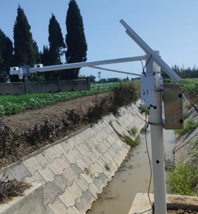
Application Scenarios:
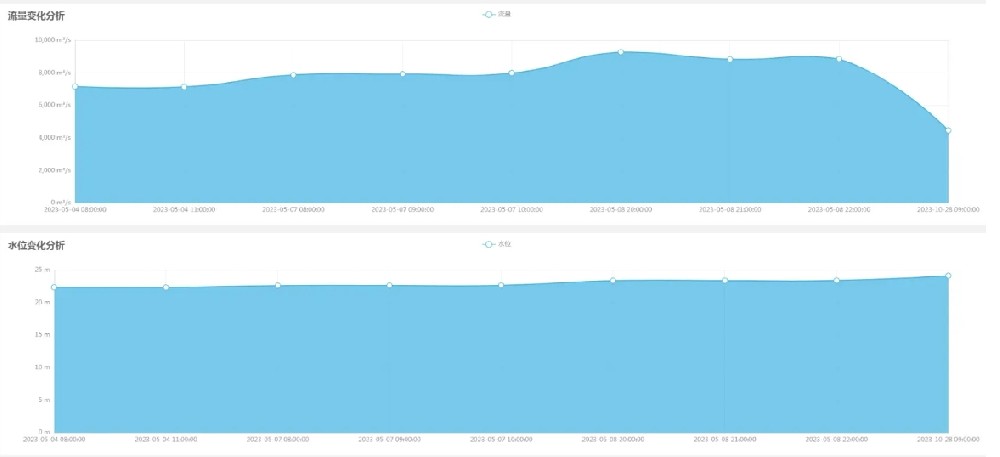
- Real-time mastery of water level, flow rate, rainfall and other data to provide a basis for flood prevention and mitigation, water resource management.
- Provide accurate meteorological data for weather forecasting and climate change research.
- Monitor soil moisture, rainfall and other parameters to guide agricultural production and improve irrigation efficiency.
- Monitor urban rainfall and water level to ensure the normal operation of the drainage system and prevent waterlogging.
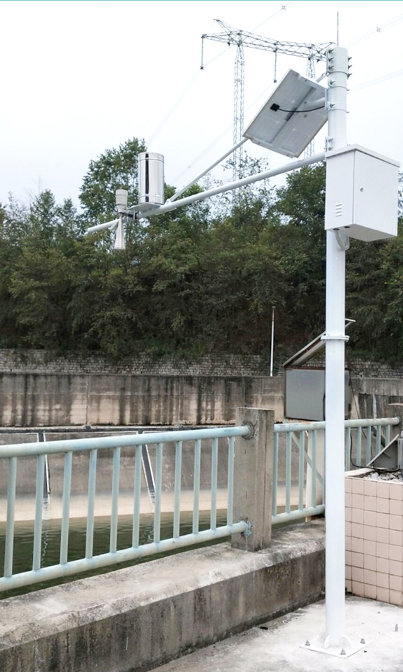
- Monitoring water quality, air quality and other environmental parameters, providing data support for environmental protection and assessing environmental pollution.
- Monitor traffic flow, speed and other data to provide data support for traffic management and planning.
- Analyze the monitoring data to detect traffic congestion, traffic accidents and other abnormal situations in time to ensure traffic safety.
- Monitor air quality, noise pollution and other indicators in the urban environment to provide data support for urban environmental management.
- Evaluate the severity of urban heat island effect and provide basis for urban planning and greening construction.
- Monitor the operation status of the urban drainage system, discover and solve drainage problems in time, and guarantee the safety of urban drainage.
- Monitoring data is an important data source for scientific research and can be used to study natural phenomena, environmental evolution and other scientific issues.
- The application of monitoring data in teaching helps students better understand natural phenomena and environmental problems, and cultivates their practical ability and scientific literacy.
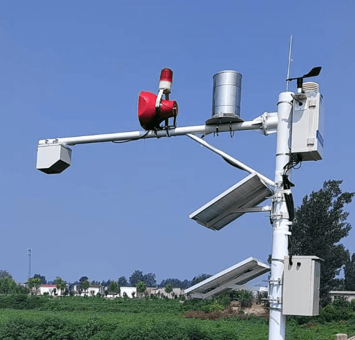
Monitoring data has a wide range of application value in many fields, and the following is a detailed description of its application aspects:
- Air quality monitoring: monitoring data can be used to assess the air quality situation, identify pollution sources, predict the trend of air quality changes, and provide scientific basis for formulating environmental protection policies and measures.
- Water quality monitoring: By monitoring the various water quality indicators in the water body, we can determine the degree and type of pollution in the water body, and provide data support for water resources protection and management.
- Soil monitoring: Monitoring the content of pollutants in soil and soil quality helps to assess the health of soil and guide agricultural production and land use planning.
- Meteorological monitoring: real-time monitoring of temperature, humidity, air pressure, wind speed and other meteorological elements in the atmosphere, providing an accurate data base for meteorological forecasting and improving the accuracy and timeliness of forecasting.
- Disaster Early Warning: By analyzing the monitoring data, the signs of meteorological disasters (such as rainstorms, typhoons, droughts, etc.) can be detected in time, and warning information can be released in advance, providing powerful support for disaster prevention and mitigation work.
- Disaster assessment: After a disaster occurs, the monitoring data can be used to assess the severity and scope of influence of the disaster, providing a scientific basis for post-disaster rescue and reconstruction work.
- Irrigation decision-making: Based on the monitored precipitation, evaporation and other data, a reasonable irrigation plan can be formulated to improve irrigation efficiency and save water resources.
- Crop growth monitoring: By monitoring soil moisture, temperature and other parameters, we can understand the growth condition of crops, guide agricultural production management, and improve crop yield and quality.
- Early warning of pests and diseases: Monitoring the temperature, humidity and other parameters in the farmland environment can predict the trend of pests and diseases, take timely preventive and control measures, and reduce the damage of pests and diseases to crops.
- Traffic condition monitoring: by monitoring traffic flow, speed and other data, we can understand the traffic condition in real time and provide data support for traffic management and planning.
- Traffic early warning: analyzing the monitoring data, you can find traffic congestion, traffic accidents and other abnormalities in a timely manner, and release early warning information in advance to ensure traffic safety.
- Traffic planning: Based on long-term monitoring data, the trend of traffic flow can be analyzed to provide a scientific basis for urban traffic planning.
- Urban environment monitoring: monitoring air quality, noise pollution and other indicators in the urban environment, providing data support for urban environment management.
- Urban heat island effect monitoring: by monitoring the temperature distribution in the city, the severity of urban heat island effect can be assessed, providing a basis for urban planning and greening construction.
- Monitoring of urban drainage system: monitoring the operation status of urban drainage system, discovering and solving drainage problems in time, and guaranteeing the safety of urban drainage.
- Scientific research: monitoring data is an important data source for scientific research, which can be used to study natural phenomena, environmental evolution and other scientific issues.
- Education and teaching: The monitoring data are applied in teaching to help students better understand natural phenomena and environmental problems, and to cultivate students' practical ability and scientific literacy.
Value of hydrometeorological station:
- Early detection of natural disaster risks such as floods and droughts to reduce disaster losses.
- Reasonable allocation of water resources, improve the efficiency of water resources utilization.
- Provide data support for ecological environmental protection and promote sustainable development.
- Provide decision-making basis for agriculture, transportation, energy and other fields to promote social and economic development.
- Enhancement of Understanding and Prediction Ability: The establishment and operation of hydrometeorological stations enhances our understanding and prediction ability of changes in the natural environment.
- Disaster prevention and mitigation: It plays an irreplaceable role in many fields such as disaster prevention and mitigation, water resource management, public safety, agricultural production and scientific research and education.
- Climate Change Response: Through in-depth analysis of these data, we can more effectively respond to the challenges posed by climate change, protect the ecological environment, and promote sustainable socio-economic development.
- Scientific bridge: In the face of increasingly complex environmental problems, hydrometeorological stations have become an important bridge for the dialog between human beings and nature, and a model for the combination of modern science and technology and environmental protection.
Conclusion
The importance of hydrometeorological stations as precise sentinels guarding nature and human life is self-evident. They provide valuable hydrometeorological information for human society through high-precision, real-time and long-term stability observation. In the future, with the progress of science and technology and the continuous innovation of observation technology, hydrometeorological stations will continue to play a greater role and contribute to the sustainable development of mankind.
Related recommendations
Sensors & Weather Stations Catalog
Agriculture Sensors and Weather Stations Catalog-NiuBoL.pdf
Weather Stations Catalog-NiuBoL.pdf
Related products
 Combined air temperature and relative humidity sensor
 Soil Moisture Temperature sensor for irrigation
 Soil pH sensor RS485 soil Testing instrument soil ph meter for agriculture
 Wind Speed sensor Output Modbus/RS485/Analog/0-5V/4-20mA
 Tipping bucket rain gauge for weather monitoring auto rainfall sensor RS485/Outdoor/stainless steel
 Pyranometer Solar Radiation Sensor 4-20mA/RS485
Screenshot, WhatsApp to identify the QR code
WhatsApp number:+8615367865107
(Click on WhatsApp to copy and add friends)