
— Blogs —
—Products—
 Consumer hotline +8618073152920
 WhatsApp:+8615367865107
Address:Room 102, District D, Houhu Industrial Park, Yuelu District, Changsha City, Hunan Province, China
Product knowledge
Time:2024-09-22 16:41:45 Popularity:1510
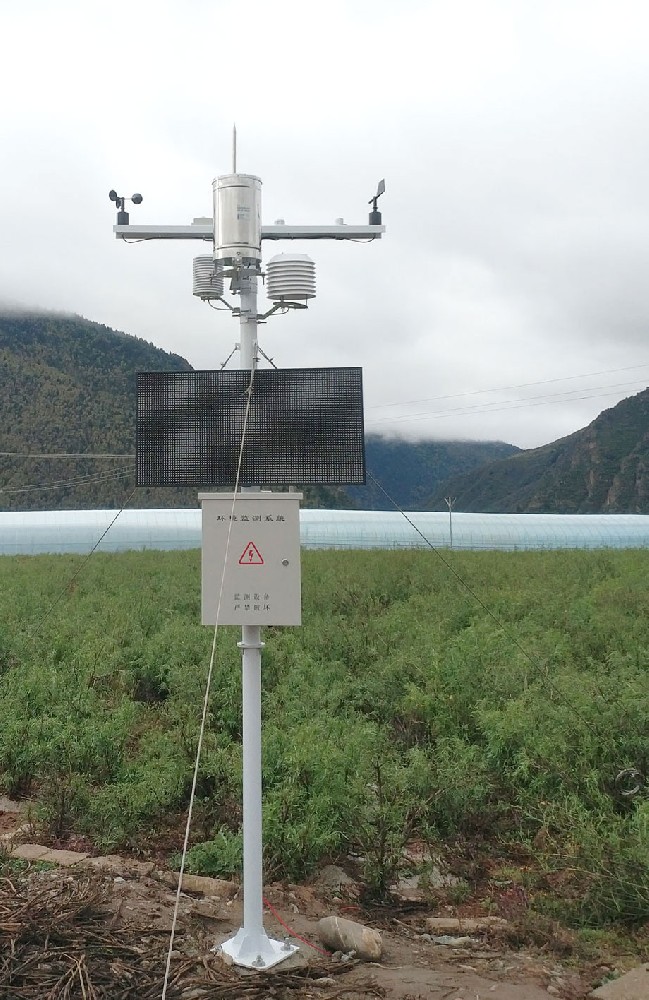
An integrated weather observation system, also known as an integrated meteorological observation system, is a comprehensive network of weather monitoring stations, sensors and communication equipment that work together to provide real-time, high-quality weather data. The system is designed to collect, process and disseminate weather information for a variety of applications, including weather forecasting, climate research, disaster management and environmental monitoring.
The system provides basic data support for a variety of fields, including weather forecasting, climate research, ecological environment monitoring, agricultural management, energy utilization, etc., through a variety of observation means, such as ground-based, space-based and space-based, and by combining data processing, technical guarantee and other systems.
Ground-based meteorological observation: including the observation of basic meteorological elements such as temperature, humidity, air pressure, wind speed, wind direction and precipitation.
Ground-based climate system observation: Specialized observation for each circle of the climate system, such as ocean observation, terrestrial ecological observation, and so on.
Ground-based Remote Sensing Observation: Utilizing remote sensing technology to obtain large-scale meteorological information, such as satellite remote sensing, radar observation, and so on.
Ground-based atmospheric boundary layer observation: fine observation of meteorological elements within the atmospheric boundary layer.
Balloon detection: Observation of the high-altitude atmosphere by releasing detection instruments carried by meteorological balloons.
Aircraft Detection: Utilizing the meteorological detection equipment carried by the aircraft to carry out high-resolution observation of the atmosphere in a specific region.
Rocket detection: by launching meteorological rockets, detect the upper atmosphere and obtain the temperature, wind speed and other parameters of the upper atmosphere.
Satellite observation: Continuous and dynamic observation of the global atmosphere using meteorological satellites to obtain a variety of meteorological information such as cloud maps, temperature, humidity, precipitation, and so on.
Includes satellite links, the Internet and other means of communication for transmitting data from observation sites to weather forecasting centers.
1. Integration:The system integrates data from different sources and platforms to provide a comprehensive view of weather conditions. 2.
2. Real-time data: The system provides up-to-the-minute weather data, which is critical for timely decision-making during severe weather events.
3. High accuracy: Advanced technology and sensors are used to ensure that the data collected is accurate and reliable.
4. Automation:Many components of the system operate automatically, reducing the need for manual observation and minimizing human error.
5. Scalability:The system can be expanded or upgraded to include additional sensors or to cover larger geographic areas.
6. Versatility: Data from the integrated system has multiple uses, including operational forecasting, research, and education.
1. Comprehensive data collection: The system is capable of integrating ground-, air- and space-based observation resources, including ground-based weather stations, automatic weather stations, weather radars, sounding systems, satellite remote sensing, etc., to achieve all-round, all-weather monitoring of atmospheric conditions. This covers the measurement of temperature, humidity, air pressure, wind speed, wind direction, precipitation, cloudiness, visibility, radiation, atmospheric composition and many other meteorological elements.
2. Real-time monitoring and early warning: With the data collected in real time, the system is able to quickly analyze weather changes and provide instant information for weather forecasting, supporting short-, medium-, and even long-term weather forecasting, as well as early warning of extreme weather events, such as typhoons, rainstorms, droughts, and cold waves.
3. Climate change research: Long-term and continuous observation data are indispensable resources for studying climate change trends and assessing the accuracy of climate models, helping scientists to understand changes in global and regional climate systems.

4. Disaster management and response: In the prevention of and response to natural disasters such as floods, landslides, and forest fires, the Integrated Weather Observing System (IWOS) provides critical meteorological information to support decision-making and reduce disaster risk.
5. Environmental and ecological monitoring: monitoring of atmospheric pollution, greenhouse gas concentration, etc. provides data support for environmental quality assessment and ecological protection.
6. Data processing and sharing: the system has efficient data processing capability, capable of standardized processing and quality control of massive observation data, and realizing data sharing through a unified platform or interface, serving many fields such as scientific research, education, agriculture, aviation, and ocean.
7. Supporting scientific research and technological progress: Observation data are the basis for research in meteorology and related earth science fields, promoting theoretical development and technological innovation, such as the optimization of numerical weather prediction models.
8. System integration and coordination: Ensure compatibility and interoperability between different observing systems, and improve observation efficiency and data consistency through unified standards and protocols.
Through these functions, the Integrated Weather Observing System provides a solid data foundation for meteorological services, disaster prevention and mitigation, scientific research and public safety, and is a core component of modern meteorological operations.
- Weather forecasting: Provide data for preparing weather forecasts and warnings.
- Climate monitoring: tracking long-term climate trends and changes.
- Disaster Management: To assist in predicting and responding to natural disasters such as hurricanes, floods, and droughts.
- Agriculture: Provides information for agricultural practices and water management.
- Aviation: Supporting flight safety and air traffic management.
- Oceans and Coastal Areas: monitoring conditions for shipping, fishing, and coastal management.

In summary, the Integrated Weather Observing System (IWOS) is an important part of the modern meteorological service system, and is of great significance in improving the accuracy of weather forecasts, responding to climate change, and protecting people's lives and property.
Related recommendations
Sensors & Weather Stations Catalog
Agriculture Sensors and Weather Stations Catalog-NiuBoL.pdf
Weather Stations Catalog-NiuBoL.pdf
Related products
 Combined air temperature and relative humidity sensor
 Soil Moisture Temperature sensor for irrigation
 Soil pH sensor RS485 soil Testing instrument soil ph meter for agriculture
 Wind Speed sensor Output Modbus/RS485/Analog/0-5V/4-20mA
 Tipping bucket rain gauge for weather monitoring auto rainfall sensor RS485/Outdoor/stainless steel
 Pyranometer Solar Radiation Sensor 4-20mA/RS485
Screenshot, WhatsApp to identify the QR code
WhatsApp number:+8615367865107
(Click on WhatsApp to copy and add friends)
